They were captured from Military unit A-1402 which was home to the 156th Air Defense Regiment.
See Wikimapia link. It is very close to Donetsk Airport.
Here is a message talking about it:
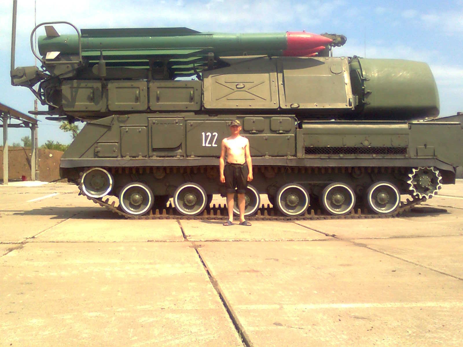
PHOTO #1

@Black_Bomb is an extreme Russian Twitter Propagandist spreading false messages continuously.
Common practice in the past Ukrainian-Russian war was/is that when Russia wanted to bring in new equipment never been used before by its local proxies, they first would publish some messages that it was captured. A couple of days later they would secretly bring in the hardware and then refer to the false messages to be able to call it 'captured'.
This had happened with the first three T64 tanks that had been brought in too. See this blog.
So, when on June 29th this message appeared it only meant one thing: they were to bring one in from Russia...
When this message came Ukraine reported that they had disabled some old equipment. See the official Ukrainian announcement on June 30th. They say they relocated the good stuff and left behind the old an unusable vehicles that had been further damaged by the war.
The location indeed had been shelled.
So we will have a look at whether these BUKs were indeed disabled.
PHOTO #2
The BUK #122 from photo #1 can also be seen on this photo on VK:

Direct link to VK-photo: http://cs4577.vk.me/u100703503/98933724/x_98e3fc4f.jpg
The tree on the background is there. The concrete wall surrounding it is also there. The concrete panels on the ground are the same, including white stripes painted on it. So the photo is made at THE SAME location.
(They do not appear to have been made at the same time though: on the first photo the tree has leaves on the second it doesn't. Yet, the LOCATION is the same.)
NOTE how there are TWO big concrete tiles on the ground between BUK #122 and the sand.
PHOTO #3
The next photo has also been used to proof that BUKs were captured (on this page for instance):

(High res version of this image)
The same two BUKs (113 loader-launch; 122 launch-radar) can be seen on the same pavement in the same position (113 a bit more forward then 122), Now they have a blue storage building behind them, so we can easily geolocate it.
That building can be found here:

Google maps link.
It is military unit 1428 (and not 1402) north of Donetsk Airport. Wikimapia link.
As can be seen on this map, they are 4 kms apart from each other:

When we zoom in we can see this:

There is a BUK there!!! With the same two tiles between it and the sand (meaning it had been driven from it's SAME spot out of the storage building as in the earlier photos):

The launcher-part is at an 45 degrees angle of the vehicle and (of course) there are no missiles on it anymore.
When we go through all the different dates available in Google Earth, we see this:

On April 7th it is not there.
On May 28th it appeared. It has the launcher-part perpendicular to it's body.
On June 19th it has its launcher at 45 degrees to it's body.
Since that date up to Sept 3rd it does not change anymore.
The presumed day of capture was June 29th. But on that day the BUK on the satellite images had its launcher already at 45 degrees! And on photo #3 it is zero degrees!
Something is wrong...
Let's see if the positions of the BUKs match.
There are white paintings on the concrete slabs. This satellite images shows them best:

Photo #3 has some distinct white stripes in front of the BUK. They can be matched with the satellite image like this:

It means BUK #113 in photo #3 is on EXACTLY the same spot as in photo #2 (which dates from October 2010!!)
When we look at the position of photo #1, we can see it is on the 5th slab from the top:

This is ANOTHER position than in photo #2, which is #7 from the top.
Photo #4
Another photo used to claim the 'captured' story:

(High res version)
This is another photo of #113 on the same spot as #2 and #3.
Conclusion 1
We must conclude that photos #1 and #2 where NOT taken at the same time, because the position was different. And photos #2 and #3 WHERE taken at the same time! Together with photo #4.
That means that photo #3 and #4 were 'old photos' used by the Russians as propaganda. They must have been shot during a visit in 2010 when the relations with Ukraine were still good.
But when this is true, it also casts doubt on the date of photo #1. Chances are this is just as good an 'old' photo from the Russian archives, but from another event!
UPDATE: @tyuebatasho points to a VK-page where photos #1 can be found dating January 2011!!!

VK-page: https://vk.com/album-22680516_124376447
Direct link to photo: https://pp.vk.me/c819/u31106954/124376447/w_56252ac7.jpg
Also photos #3 and #4 can be found here dating January 2011. But as argued above, they must have been made in October 2010 already. Even if they are from 2011, they are old and not from June 29th 2014.
Conclusion 2
What can be seen from the high res photos is that these BUKs were indeed already rusty in 2010... confirming the claim from Ukraine that these were old machines.
Conclusion 3
The fact that in May 2014 a BUK was parked outside (possibly #113) and since mid June had not been touched anymore, not even after the Russian proxies supposedly captured the base, shows this BUK was indeed disabled and useless.
This confirms the claim made by Ukraine.
Conclusion 4
But even more: military unit 1428, where the BUKs are located had never really been in Russian control! The ONLY messages about it that I could find on Twitter are that it's radar was destroyed:

End conclusion
The Russians used photos from their 2010 ARCHIVES to build their claim that BUKs were captured.
They reported the WRONG base these were captured from.
The base where the BUKS WERE located was never really in Russian control.
So they were just lying about this whole story!
It looks like they never captured ANY Ukrainian BUKs AT ALL!
By the way... the next satellite images DO show army base A-1402. As can be seen there are a lot of useless vehicles too. Some changes can be seen throughout the months (indicated with the red boxes). But NO BUKs are there. Even on the last (Sept 3rd) image there are still a lot of vehicles. This again confirms the Ukrainian claim that these are useless. The vehicles that disappeared might have been used by the Russians for spare parts.


Zoomed in on the most detailed satellite image:


Basically all the vehicles here seem to be trucks of some sort and BTRs. Maybe there might even be some GRADs, but it is hard to be conclusive on that.
This is a photo from december 2011 from INSIDE the base:

The water tower can be seen at the left on the satellite images. No BUK here either...
Thanks to @ain92ru @5urpher and @Saito_section for the help.
No comments:
Post a Comment